
[DIRECTIVE: THE_PATH_TO_2027]
This roadmap defines the ‘Lean Science’ architecture and operational milestones for the HMS Stewards 2026/2027 pilot season.
[GOVERNANCE: ADVISORY_BRAIN_TRUST]
- Founding Pillars: Industry veterans anchoring Systems Public Policy and Technical Architecture.
- Professional Reciprocity: We prioritize Wisdom over Labor, engaging technical partners through transparent, arms-length contracting for specialized builds.
[FISCAL_MODEL: SOCIAL_ENTERPRISE]
- 12% Funding for the Mission: Our commercial arm pays a 12% top-line revenue royalty to the nonprofit on all custom hardware sales. We fund the science through engineering, not just donations.
- 100% Open Data: Core hardware engineering is held by the founder, but all environmental data is a public good. The community owns the water intelligence; the commercial sales pay for it.
[TARGET_ZONE: SEACOAST_WATERSHED]
- The Five Rivers Audit: High-resolution monitoring of the Bellamy, Oyster, Lamprey, Squamscott, and Winnicut confluences.
- Interstate Scaling: Expanded tracking into Kittery, ME, and the Salmon Falls/Cochecho confluence to unlock multi-state regional grants.
- Agency Integration: Telemetry data structures optimized for direct upload into PREP and Great Bay Stewards reporting models.
[INTEL_SCALING: CITIZEN_SCIENCE_LMS]
- TIER_01: Watershed Literacy & Forensic Basics.
- TIER_02: Field Instrumentation & Sensor Calibration.
- TIER_03: Data Advocacy & Municipal Reporting Protocols.
[SYSTEMS_DIRECTIVE: OPERATIONAL_EDGE]
We build agency-grade Marine Sampling Drones (the HMS ‘Ghost’) for under $2,900, de-risking deployment into volatile environments. This low-capital, high-recovery architecture allows us to navigate high-debris forensic hotspots and sensitive habitats where $15,000 industrial sondes cannot be risked.
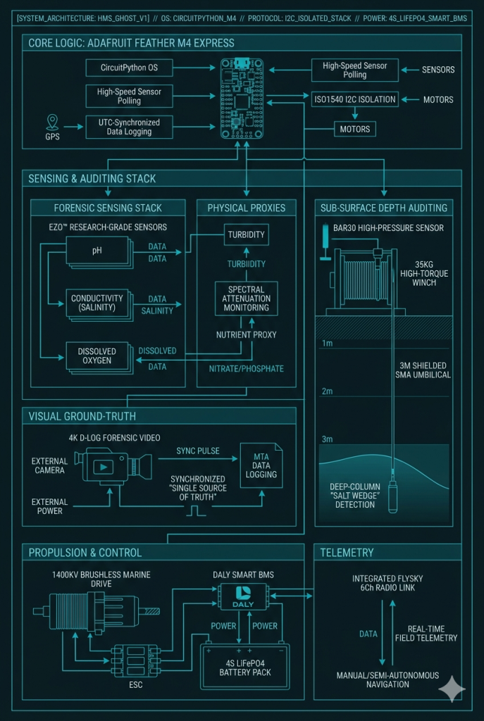
[SYSTEM_ARCHITECTURE: HMS_GHOST_V1]
- Core Logic: Feather M4 Express running CircuitPython for high-speed polling; UTC-synchronized data logging with ISO1540 I2C isolation to eliminate motor EMI.
- Forensic Sensing Stack: Research-grade EZO™ sensors for pH, Conductivity (Salinity), and Dissolved Oxygen.
- Physical Proxies: Real-time Turbidity and Spectral Attenuation to detect sediment spikes and nutrient proxies (Nitrates/Phosphates).
- Depth Auditing: Bar30 pressure sensor paired with a 35KG high-torque winch and 3m shielded SMA umbilical for deep-column “Salt Wedge” profiling.
- Continuous Visual Flight Recorder: Next-generation 1/1.3″ HDR Marine Camera system with 1TB deep-storage architecture, capturing an unbroken, high-dynamic-range visual record of the entire 6-hour transect without thermal limits.
- Propulsion & Power: 1400KV Brushless Marine Aero-Drive managed by a Daly Smart BMS and 4S LiFePO4 cells for high-current tidal ebbs.
- Telemetry: FlySky 6Ch Radio Link with real-time field telemetry for manual and semi-autonomous tracking.
[DEPLOYMENT_MODES: DUAL_PLATFORM_VERSATILITY]
| Platform | Deployment Mode | Target Environment | Tactical Advantage |
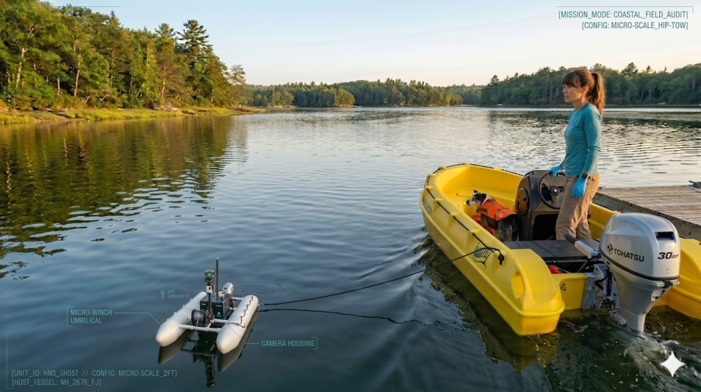
| R/V HMS BUTTERCUP (Whaly 380 HDPE/Tohatsu MFS30D) | Vessel-Mounted Trans-Estuary Profiles | Deep-channel, high-volume estuary confluences | Indestructible, 100% recyclable hull; low-emissions engine optimized for high-stability “Source-to-Sea” transects |
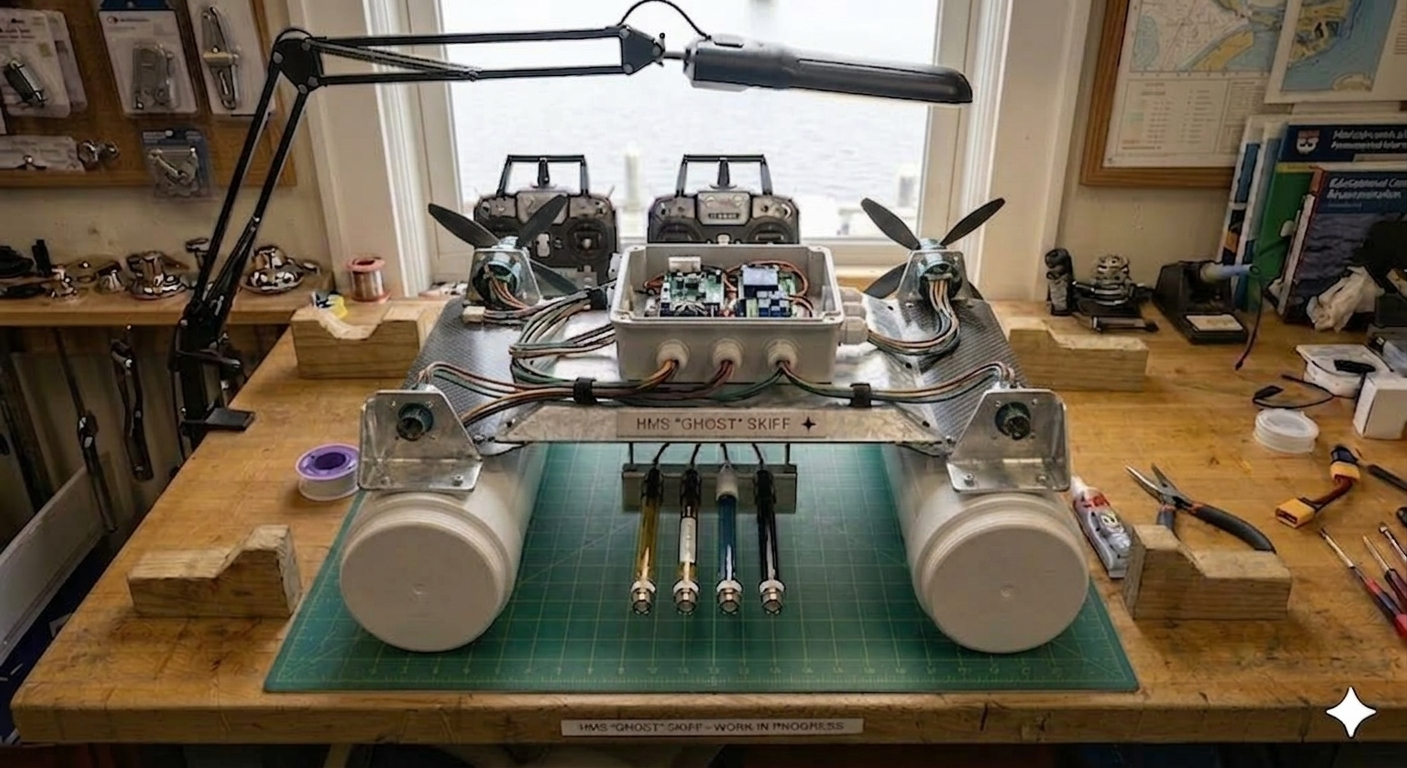
| HMS ‘GHOST‘ DRONE (6″ PVC Aero-Drive Micro-Catamaran) | Remote Pilot / Hip-Tow Micro-Catamaran | Inaccessible urban zones (e.g., North Mill Pond) and sensitive eelgrass | Zero-submergence drive prevents propeller fouling. Surgical tracking of illegal runoff and snow-dumps |
[DATA_LOGIC: ADVANCED_ANALYTE_MODELING]
Instead of relying on expensive, high-drift chemical hardware, HMS uses high-fidelity physical parameters to scout for pollution signatures:
- Chloride (Road Salt): Derived via Specific Conductance mapped against NHDES-validated curves.
- Nutrients (Nitrates/Phosphates): Turbidity and Dissolved Oxygen (DO) as “Scout” parameters.
- Trigger Protocol: Telemetry anomalies instantly generate a real-time event flag, bookmarking the exact UTC timestamp on the continuous 4K video feed and initiating physical grab-sampling for certified laboratory verification.
- Data Durability: Every mission archives as an immutable, UTC-synchronized package—overlaying the entire chemical telemetry timeline directly onto the continuous 4K forensic video to establish an indisputable evidentiary chain of custody.
[DIRECTIVE: OPERATIONAL_MILESTONES]
| Phase | Milestone | Activity Focus | Risk Profile |
| Q1 2026 DONE | Entity Formation | Federal 501(c)(3), NH State filings, Trademarking; $18,000 Founder-Funding for R&D and pilot hardware | De-Risked/Completed |
| Q2 2026 DONE | Governance | Formalize Board & D&O Insurance | Administrative |
| Q3 2026 DONE | Ops Infrastucture | Domain & Google Workspace provisioning; Google Voice telecom integration; corporate asset branding (graphics, business cards); R/V HMS BUTTERCUP hull livery/signage. | Operational Readiness |
| Q4 2026 | LMS Authoring & Kit Curation | Developing Stewardship Academy curriculum; sourcing, testing, and assembling physical water quality test kits (pH, DO, salinity, turbidity) for citizen scientists | Instructional Design/Supply Chain |
| Q1 2027 | Public Education Launch | LMS Live deployment; Stewardship Academy enrollment opens | CITIZEN SCIENCE PROGRAM ACTIVE |
| Q2 2027 | ‘Ghost‘ Drone Engineering | Prototyping sensor payloads; PCB layout & electrical isolation routing; CAD modeling for the marine chassis; edge-compute firmware programming for localized data logging | R&D (Internal) |
| Q3 2027 | The Bench Build | Hardware Procurement & Winch Assembly | R&D (Internal) |
| Q4 2027 | Capitalization | Launching “Stewards Network” monthly giving; submitting EPA/NHDES regional grants | Financial/Strategic |
| Q1 2028 | System Calibration | Sensor tuning and hardware-in-the-loop testing; drafting of the ‘Ghost‘ Drone Assembly & Technical Manuals. LMS Live deployment | R&D (Internal) |
| Q2 2028 | Field Trials | Controlled deployment in Seacoast tributaries; tidal current stress-testing; initial environmental data validation | Operational R&D |
| Q3 2028 | Robotic Sensing Begins | HMS ‘Ghost‘ begins official open-access time-series data collection | MISSION ACTIVE |
| Q4 2028 | HMS Academy Expansion | Explore lending library concept | Instructional Design |
[MISSION_SPEC: 06-HOUR_TRANS-ESTUARY_PROFILE]
| Segment | Coverage | Resolution | Data Points |
| Upper Tributary | Slow/Inland | 30ft Intervals | 720 |
| Main Channel | Tidal Ebb | 60ft Intervals | 720 |
| Bay & Coast | Macro-Trawl | Area Mapping | 720 |
| TOTAL | Source-to-Sea | Ground Truth | ~2,160+ |
Join our 2027 Steward Cohort
We’ll send you a single update once our programs are officially in place.
No spam, and absolutely no hidden “opt-ins” for anything else.